Mt. Nebo State Park
AURA Mount Nebo Fun Run 14 +/-
A few of us decided to ride up the morning of the run instead of driving up the night before and staying at the campsite. This was my first trip to this state park and the first time to get up way early to drive to the location. I was picked up at 2:40 am and then we picked up the other guy. It took us about 3.5 hours to get there but it was mostly all interstate highways so the drive was an easy one. We got off in the town of Russellville and then drove thru Dardanelle and then up Hwy 155 until it ended at Mt Nebo.
 |
| Sun rise on the Mountain |
We arrived at the site about 30 minutes before the start and had a beautiful sunrise greet us. This is a very low key fun run that is put on by the Ark Ultra Runners Association. No cost to run but asked for a small donation to help cover the drinks at the aid station. After the race they offer a small cookout.
 |
| Me enjoying the sun rise! |
The run was 14 miles approximately and you could do as many miles as you liked. You carried your own water and fuel but they did have one aid station with drinks. You would pass by this aid station 4 times during the run.
 |
| Sunrise near Rim Trailhead |
We started out in the parking lot where the pool is located. We did a loop on the pavement and then we got onto the trail at the Bench trailhead. The view on the top was just beautiful. I was stopping so much that most of the runners where long gone except for a few folks. I had already decided that this was going to be a “fun” run for sure and I was going to go easy since the Bartlett 50k race was in just weeks. I was going run/walk 1/1s at first and taking pictures at the same time. We passed a lot of deer, some running in the woods next to us and a pair of fawns on the side of the road eating.
 |
| Near the Bench trailhead |
There were two different Bench trailheads that we entered on from the road. At the beginning of the first trailhead was really rocky with some fist size rocks. The trail slowly starts the descent down but not too much and it loops all the way around the top of the mountain. You go a little less than three miles on the first loop and then you come back out on the road to head back to the trail head in a different location. When you come out on the road that is where the aid station was located.
 |
| Near the Bench trailhead |
On the second loop you do about 3.5 miles on this loop of the trail. So you are running approximately (according to my Garmin) 6+ miles on the trails and the rest is on the pavement. The trail was very shaded and the weather was nice and cool. I was running more then the 1/1s I had planned since it was a gradual decline but there were spots I had to walk so I wouldn’t inflame my IT band. I was still on my first trail loop when the first runners were making their 2nd loop around. Everyone was very friendly as they went by you. On this loop my friend, Roger, had shown up and I was running behind him for most of the way since I was still stopping and taking videos. I did have some company but not a lot. I had gotten a new pair of shorts just for this run and my ITB problems. The CW-X Expert shorts really seemed to help me with the declines of this run. I had also used Rocktape on the left ITB and across the bottom of that knee. So I am not sure which helped the most but I was very pleased. I didn’t have the usual IT pain that I had on my last long run. This was the second time to wear these shorts and I don’t regret getting them. I made sure not to run too fast going downhill since that is what really flares up my leg problem. I only took a Hammer Bar and a Luna bar to fuel on and drank plain water and did well for the 3 plus hours I was out there.
 |
| Robert going up |
 |
| One of the many switchbacks |
After we came back out on the road for a second time, we now head down Hwy 155 or you could choose to go back up to the starting line/finish line. The elevation at this location was around 1500’ and as you go down the road you encounter quite a few switchbacks. As I was going down I was now passing folks that were walking on the way back up. It was really hard to run up since it was so steep at most places. I saw a sign that said no trailers over 24’ so that goes to show how steep and tight the road was.
I was really getting nervous about this stretch of the run. It would have been so easy to run the way down but all I could think of was my ITB so I did more of a race walk down the mountain. Roger was ahead of me and now I couldn’t see him but I kept hoping to see him on the way up so I would know I was almost at the turning point. Finally ran into Robert, the other runner that went with us and he was on the way up. It seemed to take forever to go the 2 miles to the turning point and it had dropped to 488’. Finally reached the bottom of the road where it was flat again. You turn around then start the climb up. At first, it wasn’t so bad but as you got farther up the mountain the steeper it got. I finally caught up with my friend, Roger, and then we started to pass other folks that were slowly walking up.
 |
| Roger almost to the top |
 |
| View from the road almost at the top |
The incline was incredible and I couldn’t have run any of it because my heart felt like it was going to beat out of my chest but I kept going. I’m not sure of how many switchbacks we encountered but it was between 7 and 9! It seemed to take forever to climb those two miles and once we reach the location of the aid station it leveled out for a bit. I was following Roger and he headed back on the Bench trail since that is where the arrows were leading. I told him I didn’t think we should be getting back on the trail but went with him for about a tenth of a mile and then decided it wasn’t right and told him I was going to take the road up. It turns out I was right and we had to do the last bit of the hardest incline of the mountain. The view from this point was gorgeous, you could see for miles and miles.
Finally we see the parking lot and were able to start running again. We finished at 3:17 and had about 13.8 miles give or take. Most of the people were already back and was eating or leaving. They had a pool house there for those who wanted to shower before heading home. We ate hamburgers, chips and cookies. I took a nice shower and got dressed and we headed for home.
 |
| Roger and I at the finish |
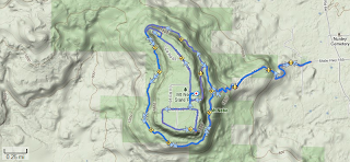 |
| Map view of route |
 |
| Climb chart |
For more pictures or videos please see my upload here.
I totally enjoyed this run and I would recommend if you live close enough to go and do it. It’s a low frill event and counts towards the AURA series points. I think the AURA did a good job with putting this on. Thanks
 |
| Until next year.... |


No comments:
Post a Comment